


SPRINGFIELD – Chronic wasting disease has been detected in Ford County, expanding the geographic presence of the infection in free-ranging deer populations in northern Illinois, the Illinois Department of Natural Resources (IDNR) announced in a news release May 1.
SPRINGFIELD, IL, - Iroquois County has been issued a final property assessment equalization factor of 1.0000, according to David Harris, director of the Illinois Department of Revenue (IDOR) in a news release.

(Family Features) If you have asthma, you know that symptoms can come on quickly, then worsen.
We will be hosting a Job Fair on Tuesday, May 14th from 12:00-4:00 PM. Area employers are hiring, including SERVPRO, United Prairie, Gilman Healthcare, and Riverside Medical Center. Please watch for more details as they become available.
April 1-30, 2024
Recent Obituaries
Watseka, IL
Right Now
67°
Partly Cloudy
- Humidity: 53%
- Feels Like: 67°
- Heat Index: 67°
- Wind: 6 mph
- Wind Chill: 67°
- UV Index: 0 Low
- Sunrise: 05:43:41 AM
- Sunset: 07:52:03 PM
- Dew Point: 49°
- Visibility: 10 mi
Today
Partly cloudy early followed by cloudy skies overnight. Low 49F. Winds NE at 5 to 10 mph.
Tonight
Partly cloudy early followed by cloudy skies overnight. Low 49F. Winds NE at 5 to 10 mph.
Tomorrow
Cloudy skies early, followed by partial clearing. Warm. High near 75F. Winds E at 10 to 15 mph.
Day
Temp
Sun
Sun
Sunday
67°/49°
Mostly cloudy. Lows overnight in the upper 40s.
Chance of Rain: 4%
Sunrise: 05:43:41 AM
Sunset: 07:52:03 PM
Humidity: 63%
Wind: NE @ 10 mph
UV Index: 0 Low
Sunday Night
Partly cloudy early followed by cloudy skies overnight. Low 49F. Winds NE at 5 to 10 mph.
Mon
Mon
Monday
75°/60°
Clouds giving way to sun . Highs in the mid 70s and lows in the low 60s.
Chance of Rain: 6%
Sunrise: 05:42:30 AM
Sunset: 07:53:05 PM
Humidity: 64%
Wind: E @ 12 mph
UV Index: 7 High
Monday Night
Partly cloudy in the evening. Increasing clouds with periods of showers after midnight. Low around 60F. Winds ESE at 10 to 15 mph. Chance of rain 70%.
Tue
Tue
Tuesday
77°/53°
Morning thunderstorms. Highs in the upper 70s and lows in the low 50s.
Chance of Rain: 90%
Sunrise: 05:41:20 AM
Sunset: 07:54:07 PM
Humidity: 74%
Wind: SSW @ 17 mph
UV Index: 7 High
Tuesday Night
Clear skies. Low 53F. Winds SW at 10 to 15 mph.
Wed
Wed
Wednesday
77°/55°
Afternoon showers and thunderstorms. Highs in the upper 70s and lows in the mid 50s.
Chance of Rain: 58%
Sunrise: 05:40:12 AM
Sunset: 07:55:09 PM
Humidity: 60%
Wind: SE @ 12 mph
UV Index: 6 High
Wednesday Night
Scattered thunderstorms in the evening, mainly cloudy late with a few showers. Potential for severe thunderstorms. Low near 55F. Winds NNE at 5 to 10 mph. Chance of rain 60%.
Thu
Thu
Thursday
64°/45°
Times of sun and clouds. Highs in the mid 60s and lows in the mid 40s.
Chance of Rain: 24%
Sunrise: 05:39:06 AM
Sunset: 07:56:10 PM
Humidity: 70%
Wind: NW @ 17 mph
UV Index: 6 High
Thursday Night
Partly cloudy. Low around 45F. Winds NNW at 10 to 20 mph.
Fri
Fri
Friday
64°/47°
Times of sun and clouds. Highs in the mid 60s and lows in the upper 40s.
Chance of Rain: 22%
Sunrise: 05:38:01 AM
Sunset: 07:57:11 PM
Humidity: 61%
Wind: NNW @ 12 mph
UV Index: 6 High
Friday Night
A few clouds. Low 47F. Winds WNW at 5 to 10 mph.
Sat
Sat
Saturday
68°/49°
Chance of showers. Highs in the upper 60s and lows in the upper 40s.
Chance of Rain: 38%
Sunrise: 05:36:57 AM
Sunset: 07:58:12 PM
Humidity: 59%
Wind: WNW @ 12 mph
UV Index: 7 High
Saturday Night
A few clouds. Low 49F. Winds WNW at 5 to 10 mph.
Local & Social Scene


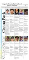
Several Iroquois County track and field teams competed at the Vermilion Valley Conference meet in Westville Thursday.

In baseball
Clifton Central track and field teams competed at the RVC meet at St. Anne.
Iroquois West track and field team members competed in Monday’s Gibson City Melvin-Sibley’s Mini Meet.
Watseka High School hosted a boys’ track and field triangular meet with Herscher and Manteno Tuesday in Watseka.